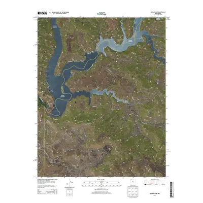
2013 Map of Navajo Dam
USGS Topo · Published 2013About this map
Navajo Reservoir dominates the high desert landscape of Northern New Mexico, where the massive Navajo Dam contains the San Juan River along the border of San Juan and Rio Arriba counties. This early 21st-century survey documents the complex shoreline and the transition from the water's edge to the high mesas and deep drainages that characterize the Four Corners region. Local landmarks like El Gobernador Knob and Smith Pass rise above the surrounding terrain, providing orientation in a region defined by dramatic erosion. The settlement of Navajo City and the specialized community at the dam provide the primary human anchors in this arid environment. Significant canyons, including Dick Earl Canyon, Negro Andy Canyon, and La Jara Canyon, cut through the northern reaches of the map, illustrating the rugged drainage system that feeds into the reservoir and shapes the local geography.
Find a feature on this map
28 named features on this map. Tap any name to fly to it.
Don’t see what you’re looking for? This feature index may not catch every label — zoom into the map to look around manually.
Map Details
Editions of this 2013 Navajo Dam Map
This is the sole edition of this map. No revisions or reprints were ever made.
Other maps of this area

1889 · Largo
USGS Topo · 1:250,000

1895 · Largo
USGS Topo · 1:250,000

1954 · Pine River
USGS Topo · 1:24,000
1954 · Burnt Mesa
USGS Topo · 1:24,000

1954 · Rosa
USGS Topo · 1:24,000

1954 · Gomez Ranch
USGS Topo · 1:24,000

1954 · Aztec
USGS Topo · 1:250,000

1958 · Aztec
USGS Topo · 1:250,000

1959 · Gould Pass
USGS Topo · 1:62,500

1959 · Navajo Dam
USGS Topo · 1:62,500