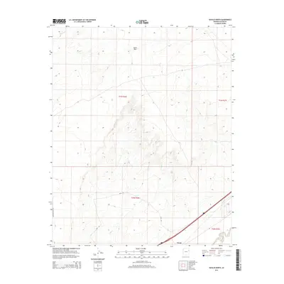
2014 Map of Navajo North
USGS Topo · Published 2014About this map
Padres Mesa dominates the northern landscape of this Apache County region, where the high desert terrain is defined by dramatic elevation shifts and seasonal drainage systems. The small settlement of Navajo serves as a central point along the southern edge, situated near the modern alignment of Road 66. This transportation corridor runs parallel to the Puerco River, which cuts through the southeastern corner of the quadrangle.
Find a feature on this map
12 named features on this map. Tap any name to fly to it.
Don’t see what you’re looking for? This feature index may not catch every label — zoom into the map to look around manually.
Map Details
Editions of this 2014 Navajo North Map
This is the sole edition of this map. No revisions or reprints were ever made.
Other maps of this area

1886 · Fort Defiance
USGS Topo · 1:250,000

1892 · Fort Defiance
USGS Topo · 1:250,000

1954 · Gallup
USGS Topo · 1:250,000

1958 · Gallup
USGS Topo · 1:250,000

1959 · Gallup
USGS Topo · 1:250,000

1962 · Gallup
USGS Topo · 1:250,000

1967 · Gallup
USGS Topo · 1:250,000
1971 · Chambers
USGS Topo · 1:24,000
1971 · Wide Ruins SW
USGS Topo · 1:24,000
1972 · Navajo Springs
USGS Topo · 1:24,000