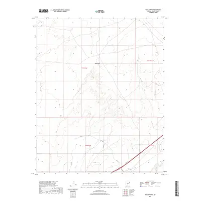
2018 Map of Navajo North
USGS Topo · Published 2018About this map
Padres Mesa dominates the northern landscape of this Apache County region, where the high desert terrain is carved by the drainages of Dead Wash and Crazy Cr. The settlement of Navajo sits in the southeastern portion of the quadrangle, serving as a focal point for the local transportation network. This infrastructure is defined by several rural routes including Kerr McGee Rd, Pinta Rd, and Co Rd 7003, which navigate the township and range divisions of T21N and T20N. In the far southeastern corner, the Puerco River cuts across the terrain, representing a vital hydrological feature in an otherwise arid landscape. The map illustrates the contemporary layout of this section of the Fort Defiance Agency, showcasing how modern roadways overlay the traditional land patterns of the Navajo Nation.
Find a feature on this map
15 named features on this map. Tap any name to fly to it.
Don’t see what you’re looking for? This feature index may not catch every label — zoom into the map to look around manually.
Map Details
Editions of this 2018 Navajo North Map
This is the sole edition of this map. No revisions or reprints were ever made.
Other maps of this area

1886 · Fort Defiance
USGS Topo · 1:250,000

1892 · Fort Defiance
USGS Topo · 1:250,000

1954 · Gallup
USGS Topo · 1:250,000

1958 · Gallup
USGS Topo · 1:250,000

1959 · Gallup
USGS Topo · 1:250,000

1962 · Gallup
USGS Topo · 1:250,000

1967 · Gallup
USGS Topo · 1:250,000
1971 · Chambers
USGS Topo · 1:24,000
1971 · Wide Ruins SW
USGS Topo · 1:24,000
1972 · Navajo Springs
USGS Topo · 1:24,000