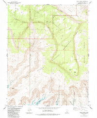
1985 Map of Navajo Point
USGS Topo · Published 1985About this map
Fiftymile Mountain dominates this mid-1980s landscape, its high plateau dropping away at the Straight Cliffs into the sprawling Glen Canyon National Recreation Area. The map records the intricate network of canyons and ridges that feed into the Colorado River basin, most notably where Lake Powell fills the lower elevations of Balanced Rock Canyon and Driftwood Canyon.
Find a feature on this map
31 named features on this map. Tap any name to fly to it.
Don’t see what you’re looking for? This feature index may not catch every label — zoom into the map to look around manually.
Map Details
Editions of this 1985 Navajo Point Map
2 editions found
Other maps of this area

1886 · Escalante
USGS Topo · 1:250,000

1886 · Henry Mountains
USGS Topo · 1:250,000

1892 · Henry Mountains
USGS Topo · 1:250,000

1953 · Cummings Mesa
USGS Topo · 1:62,500

1953 · The Rincon
USGS Topo · 1:62,500

1953 · Navajo Mountain
USGS Topo · 1:62,500

1956 · Escalante
USGS Topo · 1:250,000

1960 · Escalante
USGS Topo · 1:250,000
1968 · Blackburn Canyon
USGS Topo · 1:24,000
1968 · Sooner Bench
USGS Topo · 1:24,000