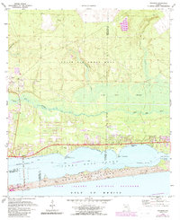
1970 Map of Navarre
USGS Topo · Published 1988About this map
Santa Rosa Island and the coastal corridor of the Florida Panhandle are captured here during a period of transition, shortly before the establishment of the Gulf Islands National Seashore was fully formalized. The landscape is defined by the heavy presence of Eglin Air Force Base, which encompasses large tracts of the northern interior around Panther Creek and Prairie Creek. Along the coastline, the development of Navarre and Wynnehaven Beach reflects the era's growing interest in recreational and residential expansion along the Santa Rosa Sound.
Find a feature on this map
34 named features on this map. Tap any name to fly to it.
Don’t see what you’re looking for? This feature index may not catch every label — zoom into the map to look around manually.
Map Details
Editions of this 1970 Navarre Map
3 editions found
Other maps of this area

1921 · Holley
USGS Topo · 1:62,500

1934 · Holt
USGS Topo · 1:48,000

1934 · Harold
USGS Topo · 1:62,500

1936 · Holley
USGS Topo · 1:48,000

1937 · Holt
USGS Topo · 1:62,500

1937 · Harold
USGS Topo · 1:62,500

1938 · Mary Esther
USGS Topo · 1:62,500

1938 · Holley
USGS Topo · 1:62,500

1938 · Harold
USGS Topo · 1:62,500

1956 · Fort Walton Beach
USGS Topo · 1:62,500