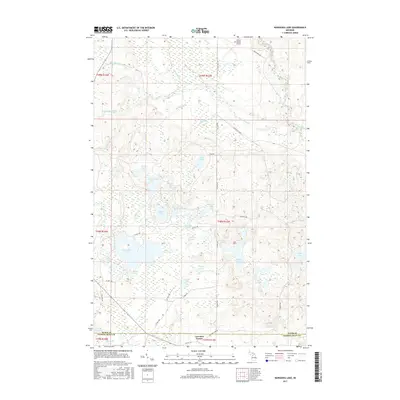
2017 Map of Nawakwa Lake
USGS Topo · Published 2017About this map
Nawakwa Lake and a dense network of smaller basins define this glaciated landscape in the Upper Peninsula. The interior is a mosaic of wetlands and timberland, drained by the Sucker River and its various tributaries including Haverstock Cr and Klondike Cr. The settlement of Lavender Corner sits at the southern edge, marking a point of human interface with the surrounding backcountry. This area is characterized by numerous named lakes such as Mitchell Lake, Sleeper Lake, and Newton Lake, which suggest a long-standing history of seasonal recreation and local fishing. Transportation is limited to a grid of county routes and forest roads like McCloud Grade and Co Hwy 781, while the northern portion of the quadrangle is served by the Grand Marais Airport. The map also illustrates the transition between Alger Co and Schoolcraft Co, with County Line Lake sitting directly on the administrative boundary.
Find a feature on this map
50 named features on this map. Tap any name to fly to it.
Don’t see what you’re looking for? This feature index may not catch every label — zoom into the map to look around manually.
Map Details
Editions of this 2017 Nawakwa Lake Map
This is the sole edition of this map. No revisions or reprints were ever made.
Other maps of this area

1931 · Seney NW
USGS Topo · 1:31,680

1931 · Driggs Lake NE
USGS Topo · 1:31,680

1954 · Sault Sainte Marie
USGS Topo · 1:250,000

1956 · Sault Sainte Marie
USGS Topo · 1:250,000

1957 · Sault Sainte Marie
USGS Topo · 1:250,000

1958 · Sault Sainte Marie
USGS Topo · 1:250,000

1958 · Marquette
USGS Topo · 1:250,000

1960 · Marquette
USGS Topo · 1:250,000

1961 · Marquette
USGS Topo · 1:250,000

1966 · Au Sable Point SE
USGS Topo · 1:24,000