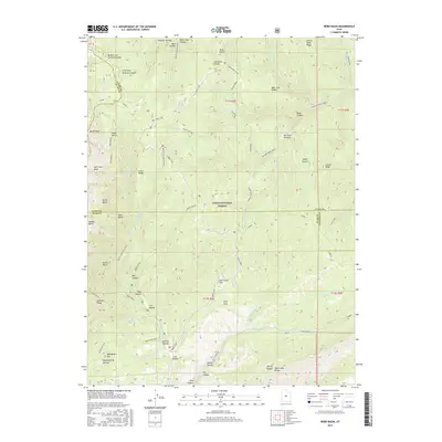
2017 Map of Nebo Basin
USGS Topo · Published 2017About this map
The Uinta National Forest dominates this high-altitude landscape where Utah County, Juab County, and Sanpete County meet. The terrain is defined by dramatic elevation changes, from the heights of North Peak and the Nebo Bench down to the drainage systems of Santaquin Canyon and the Right Fork Salt Creek. The historic Nebo Loop serves as the primary artery through this mountainous region, providing access to remote locations like Red Rock Pasture and Hell Hole Basin. This 2017 survey details a landscape where water is a vital resource, evidenced by numerous named springs and hollows such as Maple Spring and Spooner Hollow. The southern portion of the quadrangle shows the intersection of several canyons, including McCune Canyon and Lunt Hollow, near the Pole Canyon Rd, illustrating the complex topography that has shaped land use and access in this part of the Wasatch Range.
Find a feature on this map
68 named features on this map. Tap any name to fly to it.
Don’t see what you’re looking for? This feature index may not catch every label — zoom into the map to look around manually.
Map Details
Editions of this 2017 Nebo Basin Map
This is the sole edition of this map. No revisions or reprints were ever made.
Other maps of this area

1885 · Manti
USGS Topo · 1:250,000

1895 · Manti
USGS Topo · 1:250,000

1951 · Moroni
USGS Topo · 1:62,500

1951 · Santaquin
USGS Topo · 1:62,500

1951 · Nephi
USGS Topo · 1:62,500

1952 · Santaquin Peak
USGS Topo · 1:62,500

1956 · Price
USGS Topo · 1:250,000

1960 · Price
USGS Topo · 1:250,000

1962 · Price
USGS Topo · 1:250,000
1979 · Payson Lakes
USGS Topo · 1:24,000