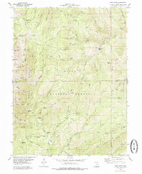
1979 Map of Nebo Basin
USGS Topo · Published 1985About this map
Uinta National Forest lands dominate this late-1970s landscape, centered on the high ridges and deep basins of the southern Wasatch Range. The drainage systems of Nebo Creek and Salt Creek define the vertical relief, with the Nebo Loop Road providing access to recreational sites like the Bear Canyon Picnic Area and Cottonwood Campground. A striking geological feature, the Devils Kitchen, stands out within the forest, showcasing the distinct erosion patterns of the area's red rock.
Find a feature on this map
57 named features on this map. Tap any name to fly to it.
Don’t see what you’re looking for? This feature index may not catch every label — zoom into the map to look around manually.
Map Details
Editions of this 1979 Nebo Basin Map
This is the sole edition of this map. No revisions or reprints were ever made.
Other maps of this area

1885 · Manti
USGS Topo · 1:250,000

1895 · Manti
USGS Topo · 1:250,000

1951 · Moroni
USGS Topo · 1:62,500

1951 · Santaquin
USGS Topo · 1:62,500

1951 · Nephi
USGS Topo · 1:62,500

1952 · Santaquin Peak
USGS Topo · 1:62,500

1956 · Price
USGS Topo · 1:250,000

1960 · Price
USGS Topo · 1:250,000

1962 · Price
USGS Topo · 1:250,000
1979 · Payson Lakes
USGS Topo · 1:24,000