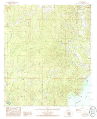
1985 Map of Nebo
USGS Topo · Published 1985About this map
Nebo and Rogers serve as the primary residential anchors in this 1980s portrait of LaSalle Parish. The landscape is defined by its intricate drainage network, with numerous named waterways like Hemphill Creek and Black Creek feeding south toward the massive expanse of Catahoula Lake. A notable industrial presence is indicated by the Gravel Pit and a Sludge Pit, hinting at the local extractive economy of the era.
Find a feature on this map
32 named features on this map. Tap any name to fly to it.
Don’t see what you’re looking for? This feature index may not catch every label — zoom into the map to look around manually.
Map Details
Editions of this 1985 Nebo Map
This is the sole edition of this map. No revisions or reprints were ever made.
Other maps of this area

1936 · Pollock
USGS Topo · 1:62,500

1941 · Jena
USGS Topo · 1:62,500

1941 · Alexandria
USGS Topo · 1:62,500

1941 · Buckeye
USGS Topo · 1:62,500

1941 · Pollock
USGS Topo · 1:62,500

1953 · Alexandria
USGS Topo · 1:250,000

1955 · Alexandria
USGS Topo · 1:250,000

1957 · Alexandria
USGS Topo · 1:62,500

1958 · Pollock
USGS Topo · 1:62,500

1958 · Jena
USGS Topo · 1:62,500