
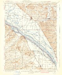
1942 Map of Nebo
USGS Topo · Published 1942About this map
Clarksville and Pleasant Hill anchor this riverfront survey, which documents the complex floodplain geography along the border of Illinois and Missouri. The Mississippi River dominates the central landscape, braiding into numerous named islands and backwater features such as Pharrs Island, Eagles Island, and the intricate Cocklebur Slough. To the west of the river, the Missouri terrain rises into a series of distinctive knobs and hills, including Akers Hill, Bethlehem Knob, and Robert Hill.
Find a feature on this map
120 named features on this map. Tap any name to fly to it.
Don’t see what you’re looking for? This feature index may not catch every label — zoom into the map to look around manually.
Map Details
Editions of this 1942 Nebo Map
2 editions found
Other maps of this area

1890 · Louisiana
USGS Topo · 1:125,000

1924 · Griggsville
USGS Topo · 1:62,500

1926 · Griggsville
USGS Topo · 1:62,500

1926 · Pittsfield
USGS Topo · 1:62,500

1930 · Pearl
USGS Topo · 1:62,500

1930 · Nebo
USGS Topo · 1:62,500

1930 · Hardin
USGS Topo · 1:62,500

1931 · Barry
USGS Topo · 1:62,500

1934 · Nebo
USGS Topo · 1:48,000

1934 · Elsberry
USGS Topo · 1:48,000