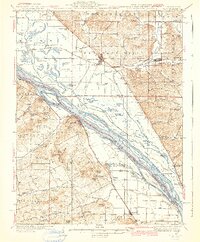
1942 Map of Nebo
USGS Topo · Published 1942About this map
Pleasant Hill and Nebo anchor this mid-century look at the river-bottom lands where the Mississippi River separates Illinois and Missouri. The landscape is defined by the intricate hydrology of the Sny Ch, a complex network of sloughs and cutoffs including Ransom Slough, Cocklebur Slough, and Lower Swan Lake that crisscross the fertile floodplains. Transportation is dominated by the Chicago And Alton and Chicago Burlington And Quincy railroads, which parallel the river and connect small settlements like Annada and Kissenger. Dozens of one-room schoolhouses, such as Franklin Sch, Oakland Sch, and Buckskin Sch, are scattered throughout the hills and hollows, reflecting a dense rural population before mid-century consolidation. Named knobs like Richardson Knob and McIlroy Knob rise sharply from the river valley, while landings like Riprap Landing suggest the importance of the river for commercial traffic and transport during this era of transitioning regional commerce.
Find a feature on this map
141 named features on this map. Tap any name to fly to it.
Don’t see what you’re looking for? This feature index may not catch every label — zoom into the map to look around manually.
Map Details
Editions of this 1942 Nebo Map
2 editions found

Other maps of this area

1890 · Louisiana
USGS Topo · 1:125,000

1924 · Griggsville
USGS Topo · 1:62,500

1926 · Griggsville
USGS Topo · 1:62,500

1926 · Pittsfield
USGS Topo · 1:62,500

1930 · Pearl
USGS Topo · 1:62,500

1930 · Nebo
USGS Topo · 1:62,500

1930 · Hardin
USGS Topo · 1:62,500

1931 · Barry
USGS Topo · 1:62,500

1934 · Nebo
USGS Topo · 1:48,000

1934 · Elsberry
USGS Topo · 1:48,000