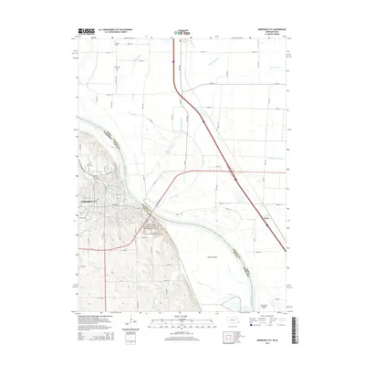
2014 Map of Nebraska City
USGS Topo · Published 2014About this map
Nebraska City sits prominently along the western banks of the Missouri River, a landscape defined by its strategic position on the bluff and its agricultural surroundings. This survey captures the town at a mature stage of development, where the grid of historic streets like Central Ave and 4th Corso meets the modern connectivity of Highway 75 and Business 75. Genealogists will find a concentration of significant burial grounds, including the large Wyuka Cem on the west side and Saint Marys Cem to the north, alongside Saint Benedicts Cem located near the bluffs. Across the river in Iowa, the terrain shifts abruptly to the low-lying floodplain of Fremont County, crisscrossed by a complex network of drainage ditches such as Horse Cr Ditch and Mule Slough Ditch. The presence of the Lewis and Clark National Historic Trail follows the river's edge, marking the enduring significance of this corridor.
Find a feature on this map
50 named features on this map. Tap any name to fly to it.
Don’t see what you’re looking for? This feature index may not catch every label — zoom into the map to look around manually.
Map Details
Editions of this 2014 Nebraska City Map
This is the sole edition of this map. No revisions or reprints were ever made.
Other maps of this area

1907 · Nebraska City
USGS Topo · 1:62,500

1935 · Nehawka
USGS Topo · 1:48,000

1939 · Hamburg
USGS Topo · 1:62,500

1940 · Nehawka
USGS Topo · 1:62,500

1941 · Hamburg
USGS Topo · 1:62,500

1955 · Nebraska City
USGS Topo · 1:250,000

1957 · Nebraska City
USGS Topo · 1:250,000

1957 · Tabor SW
USGS Topo · 1:24,000

1958 · Nebraska City
USGS Topo · 1:250,000
1966 · Nebraska City NW
USGS Topo · 1:24,000