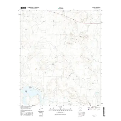
2016 Map of Necessity
USGS Topo · Published 2016About this map
Saints Rest Cem sits above the western banks of Lake Daniel in this corner of Stephens County, marking a site of local genealogical significance. The landscape is defined by the drainages of Gunsolus Cr and its E Fork Gunsolus Cr, which feed the lake alongside numerous small tributaries like Cedar Cr and Hitson Br. These water systems carve through a terrain punctuated by distinct elevations, including Beaver Mtn in the north and Steal Easy Mtn to the south.
Find a feature on this map
35 named features on this map. Tap any name to fly to it.
Don’t see what you’re looking for? This feature index may not catch every label — zoom into the map to look around manually.
Map Details
Editions of this 2016 Necessity Map
This is the sole edition of this map. No revisions or reprints were ever made.
Other maps of this area

1890 · Breckenridge
USGS Topo · 1:125,000

1931 · Ivan
USGS Topo · 1:62,500

1954 · Abilene
USGS Topo · 1:250,000

1958 · Abilene
USGS Topo · 1:250,000

1958 · Breckenridge
USGS Topo · 1:24,000

1961 · Buck Mountain
USGS Topo · 1:24,000
1967 · Wayland
USGS Topo · 1:24,000

1967 · Necessity
USGS Topo · 1:24,000
1967 · Harpersville
USGS Topo · 1:24,000
1967 · Grand Lake
USGS Topo · 1:24,000