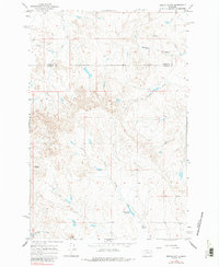
1965 Map of Needle Butte
USGS Topo · Published 1984About this map
Needle Butte and Sunday Butte stand as prominent landmarks in this high-plains landscape where Rosebud and Garfield counties meet. The drainage pattern here is defined by deeply etched seasonal watercourses such as Lone Tree Creek and Bootjack Creek, which channel moisture through the broken terrain toward the South Sunday Creek basin. This 1965 survey illustrates the livestock-driven land use of the mid-20th century, where isolated water sources like Sweetser Spring and the Sunday Creek Reservoir were critical for ranching operations in this arid Montana environment.
Find a feature on this map
11 named features on this map. Tap any name to fly to it.
Don’t see what you’re looking for? This feature index may not catch every label — zoom into the map to look around manually.
Map Details
Editions of this 1965 Needle Butte Map
2 editions found
Other maps of this area

1954 · Forsyth
USGS Topo · 1:250,000

1957 · Forsyth
USGS Topo · 1:250,000

1958 · Forsyth
USGS Topo · 1:250,000

1965 · Black Hills
USGS Topo · 1:24,000

1965 · Needle Butte Reservoir
USGS Topo · 1:24,000

1965 · Needle Butte
USGS Topo · 1:24,000

1965 · Clear Water Reservoir
USGS Topo · 1:24,000
1965 · Christenson Reservoir
USGS Topo · 1:24,000
1965 · Hillside
USGS Topo · 1:24,000

1969 · Van Burton Creek
USGS Topo · 1:24,000