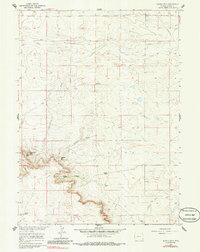
1960 Map of Needle Rock
USGS Topo · Published 1985About this map
Needle Rock and the high points of Sugar Bowl Rock dominate this section of Goshen County, mapped as part of a Missouri River Basin development program. The landscape is defined by its drainage systems and isolated homesteads, where water sources like Corn Creek and Lone Tree Creek dictated the placement of early ranching operations. The inclusion of Trelona (Site) suggests a former settlement or post office location that had already faded by the time of the 1960 survey. Family names are preserved in the geography at sites such as Hunter Ranch, Otto Ranch, and Wilkins Ranch, illustrating the sparse, livestock-driven economy of the High Plains. Steep canyon walls at Jackson Canyon and Josh Canyon contrast with the broad slopes of Needle Draw, revealing a terrain shaped by erosion and limited permanent water.
Find a feature on this map
13 named features on this map. Tap any name to fly to it.
Don’t see what you’re looking for? This feature index may not catch every label — zoom into the map to look around manually.
Map Details
Editions of this 1960 Needle Rock Map
3 editions found
Other maps of this area

1899 · Goshen Hole
USGS Topo · 1:125,000

1954 · Cheyenne
USGS Topo · 1:250,000

1958 · Cheyenne
USGS Topo · 1:250,000

1960 · Veteran
USGS Topo · 1:24,000

1960 · Diamond Flat
USGS Topo · 1:24,000

1960 · Hawk Springs
USGS Topo · 1:24,000

1960 · Needle Rock
USGS Topo · 1:24,000

1960 · Kessler Gap
USGS Topo · 1:24,000
1960 · Yoder
USGS Topo · 1:24,000

1963 · Y B O Canyon
USGS Topo · 1:24,000