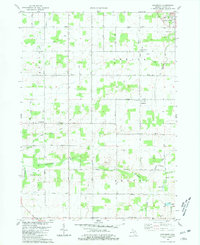
1980 Map of Needmore
USGS Topo · Published 1981About this map
Grand Ledge anchors the northeastern corner of this Eaton County landscape, which transitions from the edges of city life into a meticulously organized agricultural grid. The terrain is defined by the winding course of the Thornapple River and its tributaries, Frayer Creek and Sandstone Creek. This 1980s-era documentation reveals a rural society structured around several key intersections and townships including Roxand, Oneida, Chester, and Benton. Small settlements like Needmore and Oneida Center appear as vital local hubs, each supporting the spiritual and educational needs of the surrounding farms through sites like Needmore Ch and Oneida Gospel Ch. Notable family and community landmarks, such as Strange Cem and Pinch Cem, provide important touchstones for genealogists researching the residents of these central Michigan townships during the late twentieth century.
Find a feature on this map
29 named features on this map. Tap any name to fly to it.
Don’t see what you’re looking for? This feature index may not catch every label — zoom into the map to look around manually.
Map Details
Editions of this 1980 Needmore Map
This is the sole edition of this map. No revisions or reprints were ever made.
Other maps of this area

1910 · Lansing
USGS Topo · 1:62,500

1912 · Lansing
USGS Topo · 1:62,500

1927 · De Witt
USGS Topo · 1:62,500

1945 · Portland
USGS Topo · 1:62,500

1949 · Charlotte
USGS Topo · 1:62,500

1958 · Grand Rapids
USGS Topo · 1:250,000

1961 · Grand Rapids
USGS Topo · 1:250,000

1962 · Grand Rapids
USGS Topo · 1:250,000
1965 · Wacousta
USGS Topo · 1:24,000
1965 · Eaton Rapids
USGS Topo · 1:24,000