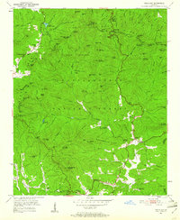
1950 Map of Neels Gap
USGS Topo · Published 1961About this map
Blood Mountain stands as the dominant peak in this mid-century survey of the North Georgia highlands, where the Chattahoochee National Forest blankets the dividing ridge between the Union and Lumpkin County lines. The area is a nexus of early recreation and mountain passage, featuring the Appalachian Trail as it winds through Neels Gap and past the borders of Vogel State Park.
Find a feature on this map
113 named features on this map. Tap any name to fly to it.
Don’t see what you’re looking for? This feature index may not catch every label — zoom into the map to look around manually.
Map Details
Editions of this 1950 Neels Gap Map
4 editions found
Other maps of this area

1886 · Dahlonega
USGS Topo · 1:125,000

1888 · Ellijay
USGS Topo · 1:125,000

1892 · Dahlonega
USGS Topo · 1:125,000

1892 · Ellijay
USGS Topo · 1:125,000

1896 · Dahlonega
USGS Topo · 1:125,000

1898 · Ellijay
USGS Topo · 1:125,000

1903 · Dahlonega
USGS Topo · 1:125,000

1911 · Ellijay
USGS Topo · 1:125,000

1935 · Coosa Bald
USGS Topo · 1:24,000

1935 · Mulky Gap
USGS Topo · 1:24,000