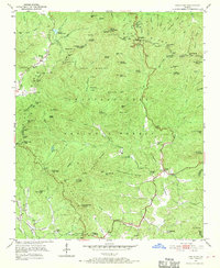
1950 Map of Neels Gap
USGS Topo · Published 1970About this map
Blood Mountain and the surrounding peaks of the Blue Ridge dominate this mid-century look at the North Georgia mountains. The high-altitude recreational character of the area is evident through Vogel State Park, the waters of Lake Winfield Scott, and the high-elevation path of the Appalachian Trail as it crosses Neels Gap. Settlement is concentrated in the gaps and along the lower watercourses, such as the Chestatee River and Yahoola Creek, where small communities like Turners Corner and Harmony Springs served the local mountain population. Deeply established rural landmarks including Mt Pisgah Sch, Damascus Ch, and Corinth Ch are grounded in the landscape. The geography is further defined by its natural wonders, including De Soto Falls and numerous gaps like Stonepile Gap and Slaughter Gap, which dictated the early travel routes through these steep ridges.
Find a feature on this map
113 named features on this map. Tap any name to fly to it.
Don’t see what you’re looking for? This feature index may not catch every label — zoom into the map to look around manually.
Map Details
Editions of this 1950 Neels Gap Map
4 editions found
Other maps of this area

1886 · Dahlonega
USGS Topo · 1:125,000

1888 · Ellijay
USGS Topo · 1:125,000

1892 · Dahlonega
USGS Topo · 1:125,000

1892 · Ellijay
USGS Topo · 1:125,000

1896 · Dahlonega
USGS Topo · 1:125,000

1898 · Ellijay
USGS Topo · 1:125,000

1903 · Dahlonega
USGS Topo · 1:125,000

1911 · Ellijay
USGS Topo · 1:125,000

1935 · Coosa Bald
USGS Topo · 1:24,000

1935 · Mulky Gap
USGS Topo · 1:24,000