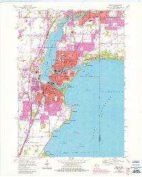
1955 Map of Neenah
USGS Topo · Published 1984About this map
The Twin Cities of Neenah and Menasha dominate this mid-century landscape where the Fox River flows from Lake Winnebago into Little Lake Butte des Morts. At the heart of the settlement lies Doty Island, split between the two municipalities and served by the Menasha Channel and Neenah Channel. The area’s industrial and educational infrastructure is densely mapped, featuring numerous schools like Nicolet Sch and Jefferson Sch, alongside the Chicago and North Western and Soo Line railroads that facilitated the regional economy.
Find a feature on this map
72 named features on this map. Tap any name to fly to it.
Don’t see what you’re looking for? This feature index may not catch every label — zoom into the map to look around manually.
Map Details
Editions of this 1955 Neenah Map
3 editions found
Other maps of this area

1911 · Neenah
USGS Topo · 1:62,500

1955 · Neenah
USGS Topo · 1:62,500

1955 · Appleton
USGS Topo · 1:24,000

1955 · Appleton
USGS Topo · 1:62,500

1955 · Neenah
USGS Topo · 1:24,000

1955 · Green Bay
USGS Topo · 1:250,000

1956 · New London
USGS Topo · 1:48,000

1961 · Oshkosh
USGS Topo · 1:24,000

1961 · Oshkosh
USGS Topo · 1:62,500

1961 · Oshkosh NE
USGS Topo · 1:24,000