
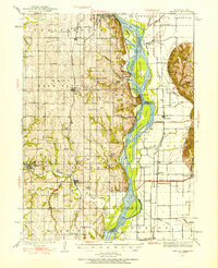
1935 Map of Nehawka
USGS Topo · Published 1935About this map
The Plattsmouth Bluffs dominate the western edge of the Missouri River valley in this 1930s survey, marking a sharp topographic transition between the upland farmsteads and the shifting river bottoms. The river's influence is evident in the numerous islands and bars such as Goose Island and Auldon Bar, while the Chicago Burlington and Quincy RR provides the primary industrial artery through the floodplain. Local civic life is exceptionally well-documented through a dense network of country schools, including Eight Mile Grove Sch and Cottonwood Sch, alongside religious landmarks like Otterbein Ch and Kings Ch. The presence of the Natural Gas Pipe Line Company of America line cutting across the terrain reflects early mid-century energy infrastructure, while the cluster of family and community cemeteries like Horning Cem and Mt Pleasant Cem provides significant data for genealogical research in this agricultural corridor.
Find a feature on this map
74 named features on this map. Tap any name to fly to it.
Don’t see what you’re looking for? This feature index may not catch every label — zoom into the map to look around manually.
Map Details
Editions of this 1935 Nehawka Map
2 editions found
Other maps of this area

1893 · Fremont
USGS Topo · 1:125,000

1896 · Fremont
USGS Topo · 1:125,000

1903 · Weeping Water
USGS Topo · 1:125,000

1907 · Nebraska City
USGS Topo · 1:62,500

1929 · Weeping Water
USGS Topo · 1:125,000

1939 · Hamburg
USGS Topo · 1:62,500

1940 · Nehawka
USGS Topo · 1:62,500

1941 · Hamburg
USGS Topo · 1:62,500

1954 · Omaha
USGS Topo · 1:250,000

1955 · Fremont
USGS Topo · 1:250,000