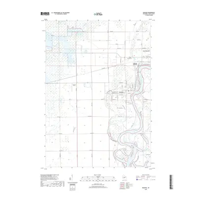
2018 Map of Nekoosa
USGS Topo · Published 2018About this map
The Wisconsin River carves a winding path through this central Wisconsin landscape, anchoring the industrial and residential centers of Nekoosa and Port Edwards. This 2018 survey reveals a distinct transition from the densely gridded streets of these riverside communities to the extensive wetlands and specialized agricultural features to the west. The area around Cranmoor Airstrip and 14-Reservoir reflects the region's long-standing connection to cranberry production, with a network of reservoirs and irrigation canals including Lunn Creek and Moccasin Creek. To the south, the river forms complex oxbows and islands near Grass Lake, while smaller tributaries like Tenmile Creek and Ripple Cr drain the surrounding timber and bog lands. Local history is preserved in the location of Port Edwards Cem and Riverside Cem, while Nekoosa Junction highlights the importance of rail connectivity in the development of the local paper and wood industries.
Find a feature on this map
49 named features on this map. Tap any name to fly to it.
Don’t see what you’re looking for? This feature index may not catch every label — zoom into the map to look around manually.
Map Details
Editions of this 2018 Nekoosa Map
This is the sole edition of this map. No revisions or reprints were ever made.
Other maps of this area

1953 · Eau Claire
USGS Topo · 1:250,000

1955 · Green Bay
USGS Topo · 1:250,000

1957 · Wisconsin Rapids
USGS Topo · 1:48,000

1957 · Pittsville
USGS Topo · 1:48,000

1958 · Eau Claire
USGS Topo · 1:250,000

1958 · Arkdale
USGS Topo · 1:48,000

1958 · Necedah
USGS Topo · 1:48,000

1964 · Eau Claire
USGS Topo · 1:250,000

1967 · Arkdale NE
USGS Topo · 1:24,000

1967 · Wisconsin Rapids
USGS Topo · 1:62,500