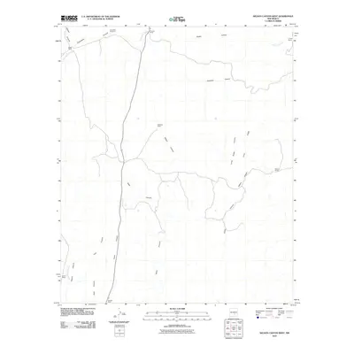
2010 Map of Nelson Canyon West
USGS Topo · Published 2010About this map
Escondido Cemetery and several generational family homesteads define this section of Lincoln County, New Mexico. The landscape is deeply carved by a network of drainage systems including Escondido Canyon, Deadman Canyon, and the central Nelson Canyon. The mapping of these features reveals a rural economy centered on ranching, as evidenced by established properties such as Wood Ranch, Sisneros Ranch, and Percella Ranch. Water is the primary driver of settlement here, with ranch life concentrated near seasonal flows like Escondido Creek and Baca Spring Creek. These canyons and ridges, such as Long Ridge, dictate the placement of local roads and primitive trails as they navigate the varying elevations of the high desert terrain.
Find a feature on this map
21 named features on this map. Tap any name to fly to it.
Don’t see what you’re looking for? This feature index may not catch every label — zoom into the map to look around manually.
Map Details
Editions of this 2010 Nelson Canyon West Map
This is the sole edition of this map. No revisions or reprints were ever made.
Other maps of this area

1935 · Capitan Mountains
USGS Topo · 1:48,000

1936 · Arabela
USGS Topo · 1:48,000

1940 · Capitan Mountains
USGS Topo · 1:62,500

1942 · Arabela
USGS Topo · 1:62,500

1955 · Roswell
USGS Topo · 1:250,000

1958 · Roswell
USGS Topo · 1:250,000

1961 · Lincoln
USGS Topo · 1:62,500

1961 · Tinnie
USGS Topo · 1:62,500

1962 · Roswell
USGS Topo · 1:250,000
1981 · Granville Canyon
USGS Topo · 1:24,000