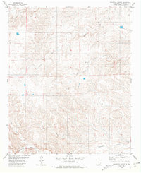
1981 Map of Granville Canyon
USGS Topo · Published 1981About this map
Granville Canyon and its complex network of seasonal drainages define this high-altitude landscape in Lincoln County. The area is characterized by deep incisions through the terrain, with watercourses like Archuleta Creek and Agua Chiquita Creek winding through the steep-walled canyons. Human presence is sparse and concentrated near established landmarks such as the Blackwater Ranch, which sits at the confluence of several landforms including the expansive Blackwater Canyon. The cartography reveals a series of secondary canyons, including Cherry Canyon, which feed into the larger Granville system. This 1981 edition, based on 1970s aerial photography, provides a detailed look at the topographic relief and ranching footprint of this portion of New Mexico before more modern development altered the land use patterns.
Find a feature on this map
10 named features on this map. Tap any name to fly to it.
Don’t see what you’re looking for? This feature index may not catch every label — zoom into the map to look around manually.
Map Details
Editions of this 1981 Granville Canyon Map
2 editions found
Other maps of this area

1936 · Arabela
USGS Topo · 1:48,000

1942 · Arabela
USGS Topo · 1:62,500

1955 · Roswell
USGS Topo · 1:250,000

1958 · Roswell
USGS Topo · 1:250,000

1961 · Tinnie
USGS Topo · 1:62,500

1962 · Roswell
USGS Topo · 1:250,000

1962 · Horseshoe Bend
USGS Topo · 1:62,500

1967 · White Flat
USGS Topo · 1:24,000
1967 · Elsie Canyon
USGS Topo · 1:24,000

1979 · Roswell
USGS Topo · 1:100,000