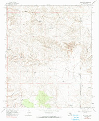
1967 Map of White Flat
USGS Topo · Published 1990About this map
White Flat and the surrounding high desert of the Lincoln and Chaves county border define this late-1960s landscape. This is a region shaped by the practical needs of livestock ranching, where survival depends on a network of water improvements such as Little Joe Tank, Big Joe Tank, and the High Lonesome Water Tank. The drainage patterns of Walnut Draw and the Middle Arroyo dictate the placement of local homesteads and infrastructure.
Find a feature on this map
21 named features on this map. Tap any name to fly to it.
Don’t see what you’re looking for? This feature index may not catch every label — zoom into the map to look around manually.
Map Details
Editions of this 1967 White Flat Map
2 editions found
Other maps of this area

1936 · Arabela
USGS Topo · 1:48,000

1942 · Arabela
USGS Topo · 1:62,500

1955 · Roswell
USGS Topo · 1:250,000

1958 · Roswell
USGS Topo · 1:250,000

1962 · Roswell
USGS Topo · 1:250,000

1967 · Round Mountain SE
USGS Topo · 1:24,000

1967 · North Lake
USGS Topo · 1:24,000

1967 · White Flat
USGS Topo · 1:24,000
1967 · White Flat SE
USGS Topo · 1:24,000
1967 · Elsie Canyon
USGS Topo · 1:24,000