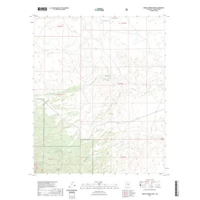
2023 Map of Arroyo Serrano West
USGS Topo · Published 2023About this map
The Capitan Mountains dominate the southern portion of this Lincoln County survey, providing a dramatic backdrop for the protected lands of the Lincoln National Forest and the more restrictive Capitan Mountains Wilderness. The landscape is defined by its drainage patterns, where significant water features like Middle Arroyo, Arroyo Seco, and Arroyo Serrano cut through the arid terrain. To the west, the isolated Lonetree Lake stands out as a unique landmark. Local topography is deeply incised by several named canyons, including Copeland Canyon, Red Lick Canyon, and Michallas Canyon, which reveal the erosional history of this high-desert environment. This map highlights the intersection of federal land management and the natural hydrological network that dictates the area's utility and character.
Find a feature on this map
16 named features on this map. Tap any name to fly to it.
Don’t see what you’re looking for? This feature index may not catch every label — zoom into the map to look around manually.
Map Details
Editions of this 2023 Arroyo Serrano West Map
This is the sole edition of this map. No revisions or reprints were ever made.
Other maps of this area

1935 · Capitan Mountains
USGS Topo · 1:48,000

1936 · Arabela
USGS Topo · 1:48,000

1940 · Capitan Mountains
USGS Topo · 1:62,500

1942 · Arabela
USGS Topo · 1:62,500

1955 · Roswell
USGS Topo · 1:250,000

1958 · Roswell
USGS Topo · 1:250,000

1962 · Roswell
USGS Topo · 1:250,000
1981 · Pedernal Arroyo
USGS Topo · 1:24,000

1981 · Huff Hill
USGS Topo · 1:24,000
1981 · Kyle Harrison Canyon
USGS Topo · 1:24,000