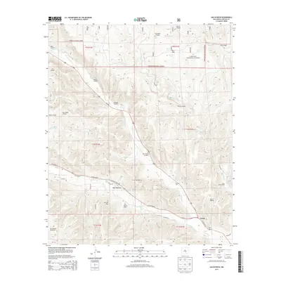
2013 Map of San Patricio
USGS Topo · Published 2013About this map
San Patricio and the settlement of Hondo anchor this landscape at the confluence of the Rio Bonito and Rio Ruidoso. These two mountain streams merge to form the Rio Hondo, creating a fertile valley corridor surrounded by the high terrain of the Lincoln National Forest and the Sacramento Mountains. The map reveals a community deeply tied to its geography and history, evidenced by landmarks like the Fritz Cem and the Peter Hurd Loop, named for the famed local artist.
Find a feature on this map
54 named features on this map. Tap any name to fly to it.
Don’t see what you’re looking for? This feature index may not catch every label — zoom into the map to look around manually.
Map Details
Editions of this 2013 San Patricio Map
This is the sole edition of this map. No revisions or reprints were ever made.
Other maps of this area

1935 · Capitan Mountains
USGS Topo · 1:48,000

1936 · Arabela
USGS Topo · 1:48,000

1940 · Capitan Mountains
USGS Topo · 1:62,500

1942 · Arabela
USGS Topo · 1:62,500

1955 · Roswell
USGS Topo · 1:250,000

1958 · Roswell
USGS Topo · 1:250,000

1961 · Lincoln
USGS Topo · 1:62,500

1961 · Tinnie
USGS Topo · 1:62,500

1962 · Roswell
USGS Topo · 1:250,000
1981 · Capitan Pass
USGS Topo · 1:24,000