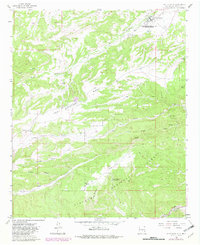
1963 Map of Fort Stanton
USGS Topo · Published 1982About this map
Fort Stanton serves as the focal point for this high-altitude landscape where the Rio Bonito flows through the high plains and rugged canyons of the Lincoln National Forest. The map documents a significant institutional footprint, notably the Fort Stanton Hospital and Training School and the nearby Camp Sierra Blanca. These landmarks, along with family-named sites like the Four K Ranch and the Red Ketchum Windmill, illustrate the intersection of state-run facilities and private ranching interests in this corner of New Mexico.
Find a feature on this map
32 named features on this map. Tap any name to fly to it.
Don’t see what you’re looking for? This feature index may not catch every label — zoom into the map to look around manually.
Map Details
Editions of this 1963 Fort Stanton Map
2 editions found
Other maps of this area

1934 · Capitan
USGS Topo · 1:48,000

1935 · Capitan Mountains
USGS Topo · 1:48,000

1937 · Capitan
USGS Topo · 1:62,500

1940 · Capitan Mountains
USGS Topo · 1:62,500

1955 · Roswell
USGS Topo · 1:250,000

1958 · Roswell
USGS Topo · 1:250,000

1961 · Lincoln
USGS Topo · 1:62,500

1962 · Roswell
USGS Topo · 1:250,000

1963 · Fort Stanton
USGS Topo · 1:24,000

1963 · Ruidoso Downs
USGS Topo · 1:24,000