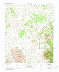
1950 Map of Little Black Peak
USGS Topo · Published 1980About this map
The Malpais dominates the southwestern portion of this mid-century New Mexico landscape, where extensive fields of Lava surround the landmark of Little Black Peak. The terrain is defined by the sharp contrast between these volcanic formations and the high country of the Lincoln Mountains and the Sacramento range to the east. Transportation and early settlement patterns follow the natural geography, with the Southern Pacific railroad skirting the Ancho Valley to connect the small outposts of Largo and Cooper. The survey reveals a region of seasonal water and deep drainages, including Largo Canyon and Ancho Gulch, with high-elevation peaks like Lone Mountain and Baxter Mountain anchoring the Lincoln National Forest boundary. Historical interest is noted in the presence of Ruins and the shifting water levels of Red Lake, illustrating the survival challenges in this arid high-desert environment.
Find a feature on this map
20 named features on this map. Tap any name to fly to it.
Don’t see what you’re looking for? This feature index may not catch every label — zoom into the map to look around manually.
Map Details
Editions of this 1950 Little Black Peak Map
3 editions found
Other maps of this area

1918 · Oscura Peak
USGS Topo · 1:125,000

1934 · Capitan
USGS Topo · 1:48,000

1937 · Capitan
USGS Topo · 1:62,500

1938 · Carrizozo
USGS Topo · 1:48,000

1943 · Carrizozo
USGS Topo · 1:62,500

1948 · Broken Back Crater
USGS Topo · 1:62,500

1948 · Chihuahua Ranch
USGS Topo · 1:62,500

1950 · Carrizozo
USGS Topo · 1:62,500

1950 · Little Black Peak
USGS Topo · 1:62,500

1954 · Tularosa
USGS Topo · 1:250,000