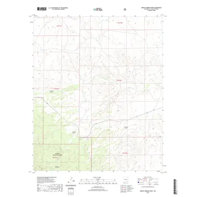
2020 Map of Arroyo Serrano West
USGS Topo · Published 2020About this map
The southern slopes of the Capitan Mountains dominate this high-desert landscape within the Lincoln National Forest. The map documents a rugged terrain defined by significant drainages and seasonal water features, including Lonetree Lake and the winding course of Arroyo Seco. Deep seasonal incisions such as Copeland Canyon, Red Lick Canyon, and Michallas Canyon carve through the foothills, illustrating the complex erosion patterns of this Lincoln County region. Human activity is sparse in this protected territory, primarily represented by administrative boundaries and transit routes like Boy Scout Rd. This 2020 edition provides a clear view of the area's natural topography, showing how names like Arroyo Serrano and Middle Arroyo trace the flow of water through the arid landscape.
Find a feature on this map
16 named features on this map. Tap any name to fly to it.
Don’t see what you’re looking for? This feature index may not catch every label — zoom into the map to look around manually.
Map Details
Editions of this 2020 Arroyo Serrano West Map
This is the sole edition of this map. No revisions or reprints were ever made.
Other maps of this area

1935 · Capitan Mountains
USGS Topo · 1:48,000

1936 · Arabela
USGS Topo · 1:48,000

1940 · Capitan Mountains
USGS Topo · 1:62,500

1942 · Arabela
USGS Topo · 1:62,500

1955 · Roswell
USGS Topo · 1:250,000

1958 · Roswell
USGS Topo · 1:250,000

1962 · Roswell
USGS Topo · 1:250,000
1981 · Pedernal Arroyo
USGS Topo · 1:24,000

1981 · Huff Hill
USGS Topo · 1:24,000
1981 · Kyle Harrison Canyon
USGS Topo · 1:24,000