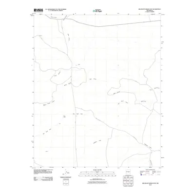
2010 Map of Red Bluff Draw East
USGS Topo · Published 2010About this map
Gallo Arroyo and Red Bluff Draw define the drainage patterns of this Lincoln County landscape, carving through a region characterized by isolated ranching sites and family-named locales. The map documents the spatial arrangement of properties such as Strickland Ranch and the Hall and Custom sites during the first decade of the 21st century. The sparse road network, primarily consisting of routes like T W RD and County RD b014, highlights the vast distances between established points of interest like Sultemier and Proctor. The intersection of natural watercourses, including Bonita Canyon and North Canyon, against the rigid grid of modern land divisions illustrates the ongoing adaptation of New Mexico's high-desert ranching culture to the environment.
Find a feature on this map
16 named features on this map. Tap any name to fly to it.
Don’t see what you’re looking for? This feature index may not catch every label — zoom into the map to look around manually.
Map Details
Editions of this 2010 Red Bluff Draw East Map
This is the sole edition of this map. No revisions or reprints were ever made.
Other maps of this area

1954 · Fort Sumner
USGS Topo · 1:250,000

1955 · Roswell
USGS Topo · 1:250,000

1958 · Fort Sumner
USGS Topo · 1:250,000

1958 · Roswell
USGS Topo · 1:250,000

1962 · Roswell
USGS Topo · 1:250,000

1980 · Corona
USGS Topo · 1:100,000

1981 · Gallo Spring Canyon
USGS Topo · 1:24,000

1981 · Cowboy Mesa SW
USGS Topo · 1:24,000
1981 · Cowboy Mesa NW
USGS Topo · 1:24,000
1981 · Juan Largo Canyon West
USGS Topo · 1:24,000