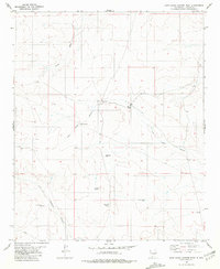
1981 Map of Juan Largo Canyon West
USGS Topo · Published 1981About this map
Richards Ranch serves as a primary human landmark in this section of Lincoln County, where the high desert landscape is defined by the deep incisions of Juan Largo Canyon and Little Hasperos Canyon. The settlement pattern reflects a ranching economy reliant on scattered water improvements, including Middle Well and several named livestock catchments like Philpot Tank and Mexican Tank. The 1981 data, based on mid-1970s aerial photography, shows a landscape of drainage draws and ranch infrastructure, such as Hines Draw and the isolated Line Camp Tank, illustrating the vast distances between reliable water sources in this part of New Mexico. The presence of a pipeline and several tanks such as Pipeline Tank indicates the managed efforts to support grazing across the dry canyon floors.
Find a feature on this map
16 named features on this map. Tap any name to fly to it.
Don’t see what you’re looking for? This feature index may not catch every label — zoom into the map to look around manually.
Map Details
Editions of this 1981 Juan Largo Canyon West Map
This is the sole edition of this map. No revisions or reprints were ever made.
Other maps of this area

1954 · Fort Sumner
USGS Topo · 1:250,000

1955 · Roswell
USGS Topo · 1:250,000

1958 · Fort Sumner
USGS Topo · 1:250,000

1958 · Roswell
USGS Topo · 1:250,000

1962 · Roswell
USGS Topo · 1:250,000

1980 · Corona
USGS Topo · 1:100,000
1981 · Pedernal Arroyo
USGS Topo · 1:24,000

1981 · Huff Hill
USGS Topo · 1:24,000

1981 · Cowboy Mesa SW
USGS Topo · 1:24,000
1981 · Cowboy Mesa
USGS Topo · 1:24,000