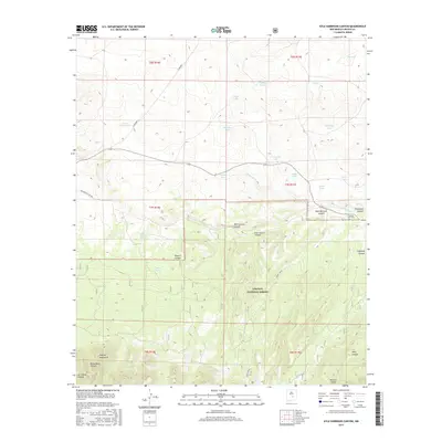
2017 Map of Kyle Harrison Canyon
USGS Topo · Published 2017About this map
Lincoln National Forest encompasses the southern portion of this high-altitude landscape, where the northern slopes of the Capitan Mountains rise above the drainage basins of the Pecos Valley. The terrain is defined by a series of deep cuts including Peppin Canyon, West Lucero Canyon, and Richardson Canyon, which channel seasonal runoff from the peaks. This arid environment is punctuated by vital water sources, such as Kyle Harrison Spring and the Seven Cabin Springs, which historically served as crucial hubs for local ranching and transit. In the flatter northern reaches, numerous natural depressions form seasonal catchments like Cactus Flat Lake and Middleton Lake. The presence of the Pleasant View Cem near Arroyo Seco provides a rare genealogical marker of early settlement in this remote portion of Lincoln County.
Find a feature on this map
35 named features on this map. Tap any name to fly to it.
Don’t see what you’re looking for? This feature index may not catch every label — zoom into the map to look around manually.
Map Details
Editions of this 2017 Kyle Harrison Canyon Map
This is the sole edition of this map. No revisions or reprints were ever made.
Other maps of this area

1935 · Capitan Mountains
USGS Topo · 1:48,000

1936 · Arabela
USGS Topo · 1:48,000

1940 · Capitan Mountains
USGS Topo · 1:62,500

1942 · Arabela
USGS Topo · 1:62,500

1955 · Roswell
USGS Topo · 1:250,000

1958 · Roswell
USGS Topo · 1:250,000

1962 · Roswell
USGS Topo · 1:250,000
1981 · Capitan Pass
USGS Topo · 1:24,000
1981 · Pedernal Arroyo
USGS Topo · 1:24,000

1981 · Huff Hill
USGS Topo · 1:24,000