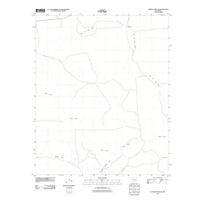
2010 Map of Cowboy Mesa SW
USGS Topo · Published 2010About this map
Gallo Arroyo and Cola del Gallo Arroyo dominate this high-desert drainage system in Lincoln County, carving a network of seasonal watercourses across the landscape. The human presence is sparse and focused around ranching operations, centered on the J Reynolds Ranch in the northern portion of the quadrangle. Transport in the area relies on a limited network of local routes, including County Rd B019 and County Rd F004. In the southern reaches, the terrain is shaped by additional drainages such as Hackberry Draw and Hines Draw, illustrating the complex natural irrigation and erosion patterns of the New Mexico interior. This 2010 survey reflects a landscape where land use remains primarily tied to large-scale ranching and the natural hydrology of the arroyos.
Find a feature on this map
7 named features on this map. Tap any name to fly to it.
Don’t see what you’re looking for? This feature index may not catch every label — zoom into the map to look around manually.
Map Details
Editions of this 2010 Cowboy Mesa SW Map
This is the sole edition of this map. No revisions or reprints were ever made.
Other maps of this area

1954 · Fort Sumner
USGS Topo · 1:250,000

1955 · Roswell
USGS Topo · 1:250,000

1958 · Fort Sumner
USGS Topo · 1:250,000

1958 · Roswell
USGS Topo · 1:250,000

1962 · Roswell
USGS Topo · 1:250,000

1980 · Corona
USGS Topo · 1:100,000

1981 · Cowboy Mesa NE
USGS Topo · 1:24,000

1981 · Cowboy Mesa SW
USGS Topo · 1:24,000
1981 · Cowboy Mesa
USGS Topo · 1:24,000
1981 · Juan Largo Canyon East
USGS Topo · 1:24,000