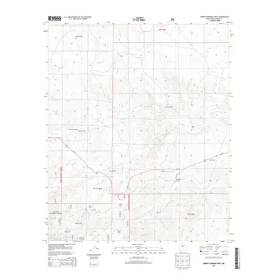
2013 Map of Arroyo Serrano West
USGS Topo · Published 2013About this map
The Capitan Mountains dominate the southern reaches of this Lincoln County landscape, where the high-altitude terrain of the Lincoln National Forest transitions into a system of expansive ranch lands. The map records a series of established family holdings, including Roberts Ranch, Purcella Ranch, and Armstrong Ranch, which are situated along the lower elevations where water courses like Arroyo Seco and Middle Arroyo define the drainage patterns.
Find a feature on this map
25 named features on this map. Tap any name to fly to it.
Don’t see what you’re looking for? This feature index may not catch every label — zoom into the map to look around manually.
Map Details
Editions of this 2013 Arroyo Serrano West Map
This is the sole edition of this map. No revisions or reprints were ever made.
Other maps of this area

1935 · Capitan Mountains
USGS Topo · 1:48,000

1936 · Arabela
USGS Topo · 1:48,000

1940 · Capitan Mountains
USGS Topo · 1:62,500

1942 · Arabela
USGS Topo · 1:62,500

1955 · Roswell
USGS Topo · 1:250,000

1958 · Roswell
USGS Topo · 1:250,000

1962 · Roswell
USGS Topo · 1:250,000
1981 · Pedernal Arroyo
USGS Topo · 1:24,000

1981 · Huff Hill
USGS Topo · 1:24,000
1981 · Kyle Harrison Canyon
USGS Topo · 1:24,000