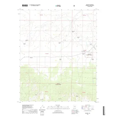
2020 Map of Encinoso
USGS Topo · Published 2020About this map
Encinoso sits at the foot of the northern slopes of the Capitan Mountains, a high-desert landscape defined by complex drainages and ranching infrastructure. This modern survey illustrates the rugged interface between public and private lands, where the Lincoln National Forest boundaries meet local holdings like the Block Ranch Airport. The terrain is deeply dissected by numerous canyons, including Encinoso Canyon, Cottonwood Canyon, and Richardson Canyon, which channel seasonal water from the high ridges toward the plains. Vital water sources for local livestock and wildlife are documented at Macho Spring, Koprian Spring, and Gum Spring. Further south, the map climbs toward higher elevations at West Mtn and Minckey Ridge, reaching a natural crossing point at Capitan Pass. The drainage patterns of Carrizo Cr and Arroyo del Macho provide a clear view of the hydraulic landscape in this part of Lincoln County.
Find a feature on this map
30 named features on this map. Tap any name to fly to it.
Don’t see what you’re looking for? This feature index may not catch every label — zoom into the map to look around manually.
Map Details
Editions of this 2020 Encinoso Map
This is the sole edition of this map. No revisions or reprints were ever made.
Other maps of this area

1934 · Capitan
USGS Topo · 1:48,000

1935 · Capitan Mountains
USGS Topo · 1:48,000

1937 · Capitan
USGS Topo · 1:62,500

1940 · Capitan Mountains
USGS Topo · 1:62,500

1955 · Roswell
USGS Topo · 1:250,000

1958 · Roswell
USGS Topo · 1:250,000

1962 · Roswell
USGS Topo · 1:250,000

1973 · Jacob Spring
USGS Topo · 1:24,000

1973 · Jicarilla Peak
USGS Topo · 1:24,000
1973 · Capitan
USGS Topo · 1:24,000