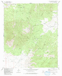
1973 Map of White Oaks South
USGS Topo · Published 1992About this map
White Oaks sits at the northern edge of this high-altitude landscape, where the mining history of the Jicarilla Mountains is written into the terrain. Just outside the settlement, the Cedarvale Cem and the Old Abe Mines mark the era of extraction, with numerous smaller Mines and a Coal Dump scattered across the nearby slopes. The central portion of the map is dominated by the Lincoln National Forest, a territory of high peaks and winding drainages including Patos Mountain and Carrizo Peak.
Find a feature on this map
106 named features on this map. Tap any name to fly to it.
Don’t see what you’re looking for? This feature index may not catch every label — zoom into the map to look around manually.
Map Details
Editions of this 1973 White Oaks South Map
This is the sole edition of this map. No revisions or reprints were ever made.
Other maps of this area

1934 · Capitan
USGS Topo · 1:48,000

1937 · Capitan
USGS Topo · 1:62,500

1938 · Carrizozo
USGS Topo · 1:48,000

1943 · Carrizozo
USGS Topo · 1:62,500

1950 · Carrizozo
USGS Topo · 1:62,500

1950 · Little Black Peak
USGS Topo · 1:62,500

1955 · Roswell
USGS Topo · 1:250,000

1958 · Roswell
USGS Topo · 1:250,000

1962 · Roswell
USGS Topo · 1:250,000

1973 · Jacob Spring
USGS Topo · 1:24,000