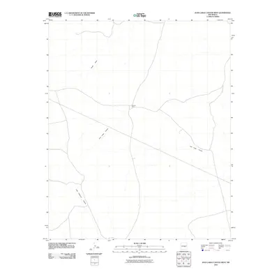
2010 Map of Juan Largo Canyon West
USGS Topo · Published 2010About this map
Juan Largo Canyon and Little Hasperos Canyon define the drainage patterns of this high-desert landscape in Lincoln County. This digital-era survey from the first decade of the 21st century reveals a sparsely populated terrain where livestock ranching and natural geography are the primary markers of human presence. The isolated Richards Ranch stands as the central landmark in a region characterized by deep arroyos and winding draws. Seasonal watercourses like Hines Draw provide the only significant hydrographic breaks in the dry upland plateaus. The map's layout of unimproved roads and 4WD tracks suggests a remote ranching economy dependent on traditional land use, even as modern GPS-ready topographic standards were applied to document the area.
Find a feature on this map
4 named features on this map. Tap any name to fly to it.
Don’t see what you’re looking for? This feature index may not catch every label — zoom into the map to look around manually.
Map Details
Editions of this 2010 Juan Largo Canyon West Map
This is the sole edition of this map. No revisions or reprints were ever made.
Other maps of this area

1954 · Fort Sumner
USGS Topo · 1:250,000

1955 · Roswell
USGS Topo · 1:250,000

1958 · Fort Sumner
USGS Topo · 1:250,000

1958 · Roswell
USGS Topo · 1:250,000

1962 · Roswell
USGS Topo · 1:250,000

1980 · Corona
USGS Topo · 1:100,000
1981 · Pedernal Arroyo
USGS Topo · 1:24,000

1981 · Huff Hill
USGS Topo · 1:24,000

1981 · Cowboy Mesa SW
USGS Topo · 1:24,000
1981 · Cowboy Mesa
USGS Topo · 1:24,000