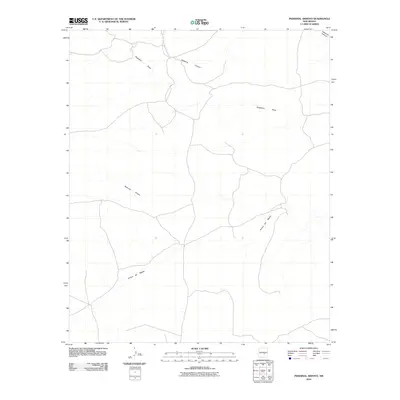
2010 Map of Pedernal Arroyo
USGS Topo · Published 2010About this map
Arroyo del Macho winds across this high desert landscape in eastern New Mexico, defining the drainage patterns of this rural Lincoln County territory. This 2010 survey by the U. S. Geological Survey captures a region dominated by ephemeral watercourses and vast open ranchland. The geography is characterized by the convergence of several major draws and canyons, including Hogadero Draw and Hasperos Canyon in the northern reaches, which direct seasonal runoff toward the larger Pedernal Arroyo. The map reveals a sparse network of local roads and tracks that navigate the subtle elevation changes of the plains, reflecting a landscape where land use is tied closely to the natural contours of the arroyos. Researchers will find a precise record of the terrain before more recent shifts in land management or climate impacted these sensitive New Mexico water systems.
Find a feature on this map
4 named features on this map. Tap any name to fly to it.
Don’t see what you’re looking for? This feature index may not catch every label — zoom into the map to look around manually.
Map Details
Editions of this 2010 Pedernal Arroyo Map
This is the sole edition of this map. No revisions or reprints were ever made.
Other maps of this area

1935 · Capitan Mountains
USGS Topo · 1:48,000

1936 · Arabela
USGS Topo · 1:48,000

1940 · Capitan Mountains
USGS Topo · 1:62,500

1942 · Arabela
USGS Topo · 1:62,500

1955 · Roswell
USGS Topo · 1:250,000

1958 · Roswell
USGS Topo · 1:250,000

1962 · Roswell
USGS Topo · 1:250,000
1981 · Pedernal Arroyo
USGS Topo · 1:24,000

1981 · Huff Hill
USGS Topo · 1:24,000
1981 · Encinoso
USGS Topo · 1:24,000