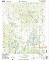
2004 Map of White Oaks North
USGS Topo · Published 2006About this map
The Jicarilla Mountains dominate the northern terrain of this New Mexico landscape, where the settlement of Jicarilla remains a focal point for local history. This area, largely contained within the Lincoln National Forest, reflects a legacy of resource extraction and high-altitude ranching. Evidence of early infrastructure is visible through the Jicarilla Sch and the Jicarilla Cem, while numerous notations for prospects and mines dot the slopes of Ancho Peak and the surrounding gulches.
Find a feature on this map
76 named features on this map. Tap any name to fly to it.
Don’t see what you’re looking for? This feature index may not catch every label — zoom into the map to look around manually.
Map Details
Editions of this 2004 White Oaks North Map
This is the sole edition of this map. No revisions or reprints were ever made.
Other maps of this area

1934 · Capitan
USGS Topo · 1:48,000

1937 · Capitan
USGS Topo · 1:62,500

1938 · Carrizozo
USGS Topo · 1:48,000

1943 · Carrizozo
USGS Topo · 1:62,500

1950 · Carrizozo
USGS Topo · 1:62,500

1950 · Little Black Peak
USGS Topo · 1:62,500

1955 · Roswell
USGS Topo · 1:250,000

1958 · Roswell
USGS Topo · 1:250,000

1962 · Roswell
USGS Topo · 1:250,000

1973 · Ancho
USGS Topo · 1:24,000