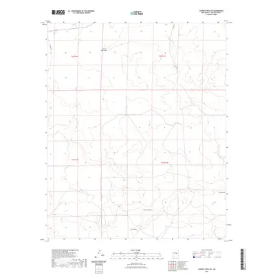
2023 Map of Cowboy Mesa SW
USGS Topo · Published 2023About this map
Cola del Gallo Arroyo and Gallo Arroyo define the hydrological character of this high desert landscape in Lincoln County. This portion of the New Mexico interior is marked by significant topographical relief, where seasonal drainages like Hackberry Draw and Hines Draw have carved distinct paths through the mesa country. The land is organized by the Public Land Survey System, evidenced by the section lines of t2s r16e, t2s r17e, t3s r16e, and t3s r17e. Remote access to these expansive tracts of land is maintained through gravel routes such as Co RD b018 and Co RD b019, which navigate the high elevations. The map reveals a sparsely populated environment where the natural drainage system remains the most prominent structural feature of the terrain.
Find a feature on this map
10 named features on this map. Tap any name to fly to it.
Don’t see what you’re looking for? This feature index may not catch every label — zoom into the map to look around manually.
Map Details
Editions of this 2023 Cowboy Mesa SW Map
This is the sole edition of this map. No revisions or reprints were ever made.
Other maps of this area

1954 · Fort Sumner
USGS Topo · 1:250,000

1955 · Roswell
USGS Topo · 1:250,000

1958 · Fort Sumner
USGS Topo · 1:250,000

1958 · Roswell
USGS Topo · 1:250,000

1962 · Roswell
USGS Topo · 1:250,000

1980 · Corona
USGS Topo · 1:100,000

1981 · Cowboy Mesa NE
USGS Topo · 1:24,000

1981 · Cowboy Mesa SW
USGS Topo · 1:24,000
1981 · Cowboy Mesa
USGS Topo · 1:24,000
1981 · Juan Largo Canyon East
USGS Topo · 1:24,000