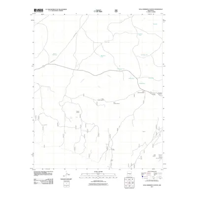
2011 Map of Kyle Harrison Canyon
USGS Topo · Published 2011About this map
Kyle Harrison Canyon and the surrounding drainage of Arroyo Seco define this high-altitude landscape in the early twenty-first century. This survey records a transition from the rugged canyons of the south, where mining operations like Ajax Mine, Major Mine, and Red Wing Number Three Mine mark the slopes of Kelly Canyon, to a northern plateau dotted with seasonal water bodies. The presence of Fox and Fur Lodge and the remote outpost at Seven Cabins suggests a region utilized for recreation and ranching rather than dense settlement. Genealogists and local historians can locate Pleasant View Cemetery near Peachtree Canyon, while the numerous named basins such as Deep Lake and Cactus Flat Lake illustrate the vital importance of water catchments in this arid environment.
Find a feature on this map
27 named features on this map. Tap any name to fly to it.
Don’t see what you’re looking for? This feature index may not catch every label — zoom into the map to look around manually.
Map Details
Editions of this 2011 Kyle Harrison Canyon Map
This is the sole edition of this map. No revisions or reprints were ever made.
Other maps of this area

1935 · Capitan Mountains
USGS Topo · 1:48,000

1936 · Arabela
USGS Topo · 1:48,000

1940 · Capitan Mountains
USGS Topo · 1:62,500

1942 · Arabela
USGS Topo · 1:62,500

1955 · Roswell
USGS Topo · 1:250,000

1958 · Roswell
USGS Topo · 1:250,000

1962 · Roswell
USGS Topo · 1:250,000
1981 · Capitan Pass
USGS Topo · 1:24,000
1981 · Pedernal Arroyo
USGS Topo · 1:24,000

1981 · Huff Hill
USGS Topo · 1:24,000