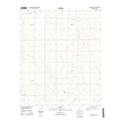
2013 Map of Cowboy Mesa SW
USGS Topo · Published 2013About this map
J Reynolds Ranch stands as a primary landmark in this high-desert landscape of Lincoln County, where the terrain is defined by a network of ephemeral watercourses and deep-cut draws. The drainage pattern is dominated by the Gallo Arroyo and its tributary, Cola del Gallo Arroyo, which carve through the northern and southern reaches of the quadrangle. Other significant topographical features include the winding Bonita Canyon and the dry beds of Hackberry Draw and Hines Draw. Transport through this arid ranching country relies on the paved corridor of NM-247 in the northwest, supplemented by rural routes such as CO Road 8019 and CO Road F004. This 2013 survey illustrates the enduring nature of New Mexico's land divisions, showing the grid-like Public Land Survey System boundaries spanning the sections of Township 2 and 3 South.
Find a feature on this map
14 named features on this map. Tap any name to fly to it.
Don’t see what you’re looking for? This feature index may not catch every label — zoom into the map to look around manually.
Map Details
Editions of this 2013 Cowboy Mesa SW Map
This is the sole edition of this map. No revisions or reprints were ever made.
Other maps of this area

1954 · Fort Sumner
USGS Topo · 1:250,000

1955 · Roswell
USGS Topo · 1:250,000

1958 · Fort Sumner
USGS Topo · 1:250,000

1958 · Roswell
USGS Topo · 1:250,000

1962 · Roswell
USGS Topo · 1:250,000

1980 · Corona
USGS Topo · 1:100,000

1981 · Cowboy Mesa NE
USGS Topo · 1:24,000

1981 · Cowboy Mesa SW
USGS Topo · 1:24,000
1981 · Cowboy Mesa
USGS Topo · 1:24,000
1981 · Juan Largo Canyon East
USGS Topo · 1:24,000