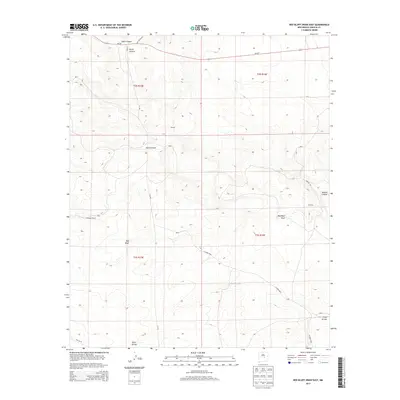
2013 Map of Red Bluff Draw East
USGS Topo · Published 2013About this map
Strickland Ranch and the small settlement of Proctor anchor this high-desert landscape in Lincoln County, where the topography is defined by a complex network of dry washes and drainage draws. The area around Red Bluff is marked by significant elevation changes, with Gallo Canyon and North Canyon cutting through the northern reaches near NM-247. This 2013 survey reveals the sparse but intentional human presence in the region, centered on ranching and the management of water resources in an arid environment. A series of backcountry routes, including Red Canyon Rd and T W Rd, connect isolated points like Towning and provide access across the deep incisions of Jesus Canyon and Red Bluff Draw. The southern portion of the quadrangle is dominated by broader drainages like Hackberry Draw and Gallo Arroyo, illustrating the expansive hydrological patterns of the New Mexico interior.
Find a feature on this map
21 named features on this map. Tap any name to fly to it.
Don’t see what you’re looking for? This feature index may not catch every label — zoom into the map to look around manually.
Map Details
Editions of this 2013 Red Bluff Draw East Map
This is the sole edition of this map. No revisions or reprints were ever made.
Other maps of this area

1954 · Fort Sumner
USGS Topo · 1:250,000

1955 · Roswell
USGS Topo · 1:250,000

1958 · Fort Sumner
USGS Topo · 1:250,000

1958 · Roswell
USGS Topo · 1:250,000

1962 · Roswell
USGS Topo · 1:250,000

1980 · Corona
USGS Topo · 1:100,000

1981 · Gallo Spring Canyon
USGS Topo · 1:24,000

1981 · Cowboy Mesa SW
USGS Topo · 1:24,000
1981 · Cowboy Mesa NW
USGS Topo · 1:24,000
1981 · Juan Largo Canyon West
USGS Topo · 1:24,000