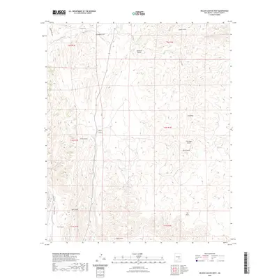
2023 Map of Nelson Canyon West
USGS Topo · Published 2023About this map
Escondido Cem sits on the northern edge of this Lincoln County landscape, a vital point of reference for genealogists tracking local families. The terrain is defined by a dense network of drainages and ridges, where Escondido Creek and Stinking Creek cut through the high ground. The naming of these landmarks, from Deadman Canyon to Chavez Canyon and Nelson Canyon, reflects the area's grazing and homesteading history. The mapping of township and range lines like t10s r17e across this complex topography shows the systematic division of public lands. In the southern portion, seasonal water sources like Baca Spring Creek and the deep cuts of Talley Canyon and Trail Canyon illustrate the watershed patterns essential to the ranching economy of this part of New Mexico.
Find a feature on this map
26 named features on this map. Tap any name to fly to it.
Don’t see what you’re looking for? This feature index may not catch every label — zoom into the map to look around manually.
Map Details
Editions of this 2023 Nelson Canyon West Map
This is the sole edition of this map. No revisions or reprints were ever made.
Other maps of this area

1935 · Capitan Mountains
USGS Topo · 1:48,000

1936 · Arabela
USGS Topo · 1:48,000

1940 · Capitan Mountains
USGS Topo · 1:62,500

1942 · Arabela
USGS Topo · 1:62,500

1955 · Roswell
USGS Topo · 1:250,000

1958 · Roswell
USGS Topo · 1:250,000

1961 · Lincoln
USGS Topo · 1:62,500

1961 · Tinnie
USGS Topo · 1:62,500

1962 · Roswell
USGS Topo · 1:250,000
1981 · Granville Canyon
USGS Topo · 1:24,000