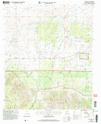
2004 Map of Encinoso
USGS Topo · Published 2006About this map
Encinoso sits at the northern edge of the Capitan Mountains, serving as a focal point for this high-altitude landscape in Lincoln County. The map captures a transition from the lower ranch lands, including the notable Block Ranch and Edgar Ranch, into the protected timber of the Lincoln National Forest. Water sources are critical here, evidenced by the presence of Macho Spring, Koprian Spring, and Gum Spring fueling the drainage network of Patos Creek and Carrizo Creek. The presence of the Capitan Mountains Wilderness highlights the preservation of this sharp topography, where names like Merchant Canyon and Shoemaker Canyon define the northern slopes. Local industry and habitation are marked by small Gravel Pits, a Comm Facility, and the Sportsmans Lodge, indicating a mix of utility and mountain recreation.
Find a feature on this map
38 named features on this map. Tap any name to fly to it.
Don’t see what you’re looking for? This feature index may not catch every label — zoom into the map to look around manually.
Map Details
Editions of this 2004 Encinoso Map
This is the sole edition of this map. No revisions or reprints were ever made.
Other maps of this area

1934 · Capitan
USGS Topo · 1:48,000

1935 · Capitan Mountains
USGS Topo · 1:48,000

1937 · Capitan
USGS Topo · 1:62,500

1940 · Capitan Mountains
USGS Topo · 1:62,500

1955 · Roswell
USGS Topo · 1:250,000

1958 · Roswell
USGS Topo · 1:250,000

1962 · Roswell
USGS Topo · 1:250,000

1973 · Jacob Spring
USGS Topo · 1:24,000

1973 · Jicarilla Peak
USGS Topo · 1:24,000
1973 · Capitan
USGS Topo · 1:24,000