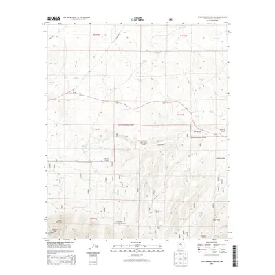
2013 Map of Kyle Harrison Canyon
USGS Topo · Published 2013About this map
The Lincoln National Forest dominates the southern half of this landscape, where the northern slopes of the Capitan Mountains rise sharply. The terrain is defined by a series of north-trending drainages including Kyle Harrison Canyon, Peppin Canyon, and Copeland Canyon. Settlement patterns are sparse, represented by small clusters such as Seven Cabins and the Fox and Fur Lodge near Seven Cabin Springs. To the north, the elevation levels out into a plateau punctuated by numerous ephemeral bodies of water like Antelope Lake, Middleton Lake, and Cactus Flat Lake. Traces of local history are preserved at the Pleasant View Cem near the eastern boundary, while the winding path of NM-246 serves as the primary corridor through the high-desert scrub and canyons.
Find a feature on this map
40 named features on this map. Tap any name to fly to it.
Don’t see what you’re looking for? This feature index may not catch every label — zoom into the map to look around manually.
Map Details
Editions of this 2013 Kyle Harrison Canyon Map
This is the sole edition of this map. No revisions or reprints were ever made.
Other maps of this area

1935 · Capitan Mountains
USGS Topo · 1:48,000

1936 · Arabela
USGS Topo · 1:48,000

1940 · Capitan Mountains
USGS Topo · 1:62,500

1942 · Arabela
USGS Topo · 1:62,500

1955 · Roswell
USGS Topo · 1:250,000

1958 · Roswell
USGS Topo · 1:250,000

1962 · Roswell
USGS Topo · 1:250,000
1981 · Capitan Pass
USGS Topo · 1:24,000
1981 · Pedernal Arroyo
USGS Topo · 1:24,000

1981 · Huff Hill
USGS Topo · 1:24,000