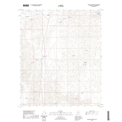
2020 Map of Nelson Canyon West
USGS Topo · Published 2020About this map
Escondido Cem stands on a high point above the drainage of Escondido Cr, marking a quiet historical presence in this section of Lincoln County. The landscape is defined by an intricate network of deep arroyos and canyons, including the significant Nelson Canyon and Diablo Canyon systems. These drainages reveal a topography shaped by seasonal water flow, with Stinking Cr and Baca Spring Cr cutting through the arid terrain. The map's detail provides a record of the early 21st-century land divisions across townships like t10s r18e, where the names of features like Deadman Canyon and Trail Canyon suggest a history of early movement and ranching activity through the gaps in Long Ridge.
Find a feature on this map
25 named features on this map. Tap any name to fly to it.
Don’t see what you’re looking for? This feature index may not catch every label — zoom into the map to look around manually.
Map Details
Editions of this 2020 Nelson Canyon West Map
This is the sole edition of this map. No revisions or reprints were ever made.
Other maps of this area

1935 · Capitan Mountains
USGS Topo · 1:48,000

1936 · Arabela
USGS Topo · 1:48,000

1940 · Capitan Mountains
USGS Topo · 1:62,500

1942 · Arabela
USGS Topo · 1:62,500

1955 · Roswell
USGS Topo · 1:250,000

1958 · Roswell
USGS Topo · 1:250,000

1961 · Lincoln
USGS Topo · 1:62,500

1961 · Tinnie
USGS Topo · 1:62,500

1962 · Roswell
USGS Topo · 1:250,000
1981 · Granville Canyon
USGS Topo · 1:24,000