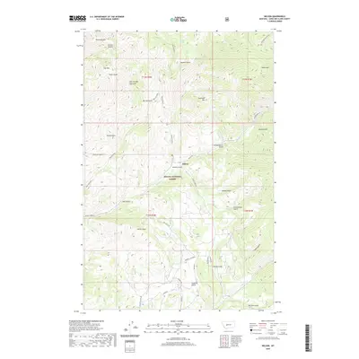
2020 Map of Nelson
USGS Topo · Published 2020About this map
Nelson lies at the heart of this landscape, situated within the protected bounds of the Helena National Forest. The area is defined by a dense network of gulches and canyons that carve through the high peaks of the Big Belt Mountains, including Sacajawea Mtn, Sawtooth Mtn, and Sheep Mtn. Steep drainage systems like Refrigerator Canyon and Coulter Canyon reveal the complex verticality of the terrain, where water sources such as Turnout Spring and Beaver Cr provided critical resources for early Montana backcountry travel.
Find a feature on this map
44 named features on this map. Tap any name to fly to it.
Don’t see what you’re looking for? This feature index may not catch every label — zoom into the map to look around manually.
Map Details
Editions of this 2020 Nelson Map
This is the sole edition of this map. No revisions or reprints were ever made.
Other maps of this area

1886 · Fort Logan
USGS Topo · 1:250,000

1899 · Helena
USGS Topo · 1:62,500

1948 · White Sulphur Springs
USGS Topo · 1:250,000

1950 · Canyon Ferry
USGS Topo · 1:62,500

1950 · East Helena
USGS Topo · 1:62,500

1958 · White Sulphur Springs
USGS Topo · 1:250,000

1961 · White Sulphur Springs
USGS Topo · 1:250,000
1962 · Upper Holter Lake
USGS Topo · 1:24,000

1962 · Hogback Mountain
USGS Topo · 1:24,000
1962 · Beartooth Mountain
USGS Topo · 1:24,000