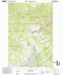
2001 Map of Nelson
USGS Topo · Published 2004About this map
Helena National Forest dominates this landscape in Lewis and Clark County, where the sharp transition between valley floors and high peaks is clearly documented. The small settlement of Nelson serves as a central landmark amidst a complex drainage system that includes Beaver Creek and Favorite Gulch. To the north, the protected Gates of the Mountains Wilderness encompasses rugged heights such as Sacajawea Mountain and Cap Mtn, reflecting the preservation of the Montana backcountry. The map captures a moment of modern land management, showing a significant Pipeline corridor cutting through the terrain alongside family-named landmarks like Cochran Gulch and Potts Gulch. This 2001 revision, based on earlier surveys, provides a detailed record of the road and trail network that facilitates movement through the wilderness and the forest.
Find a feature on this map
32 named features on this map. Tap any name to fly to it.
Don’t see what you’re looking for? This feature index may not catch every label — zoom into the map to look around manually.
Map Details
Editions of this 2001 Nelson Map
This is the sole edition of this map. No revisions or reprints were ever made.
Other maps of this area

1886 · Fort Logan
USGS Topo · 1:250,000

1899 · Helena
USGS Topo · 1:62,500

1948 · White Sulphur Springs
USGS Topo · 1:250,000

1950 · Canyon Ferry
USGS Topo · 1:62,500

1950 · East Helena
USGS Topo · 1:62,500

1958 · White Sulphur Springs
USGS Topo · 1:250,000

1961 · White Sulphur Springs
USGS Topo · 1:250,000
1962 · Upper Holter Lake
USGS Topo · 1:24,000

1962 · Hogback Mountain
USGS Topo · 1:24,000
1962 · Beartooth Mountain
USGS Topo · 1:24,000