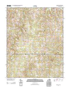
2013 Map of Nelson
USGS Topo · Published 2013About this map
Buffalo Junction and the small agricultural crossroads of southern Mecklenburg County characterize this rural landscape near the North Carolina border. The terrain is defined by a dense network of streams, notably Buffalo Cr and Aarons Cr, which historically powered the local milling industry. Remnants of this early economy are visible in the locations of Heights Mill and Willards Mill.
Find a feature on this map
90 named features on this map. Tap any name to fly to it.
Don’t see what you’re looking for? This feature index may not catch every label — zoom into the map to look around manually.
Map Details
Editions of this 2013 Nelson Map
This is the sole edition of this map. No revisions or reprints were ever made.
Other maps of this area

1941 · Clarksville
USGS Topo · 1:48,000

1943 · Clarksville
USGS Topo · 1:62,500

1943 · Roxboro
USGS Topo · 1:62,500

1953 · Oxford
USGS Topo · 1:62,500

1953 · South Boston
USGS Topo · 1:62,500

1953 · Greensboro
USGS Topo · 1:250,000

1954 · Greensboro
USGS Topo · 1:250,000

1957 · South Boston
USGS Topo · 1:62,500

1957 · Clarksville
USGS Topo · 1:62,500

1962 · Greensboro
USGS Topo · 1:250,000